Mapping Michigan
Maps today are commonplace. It was not, however, always so. Three
hundred years ago the most sophisticated mapmakers of Europe had only
the vaguest notions about North America's interior. Slowly, the
knowledge of early European visitors to the Great
Lakes region found its way onto published maps.
As
European maps of the Great Lakes shoreline became more accurate, maps
took on additional uses. Maps evolved from descriptions of natural
geography to documents recording human concepts and impact upon the
land. For example, in the nineteenth century
maps were printed with imaginary grids drawn over the natural
topography. These survey maps were created at the behest of the federal
government and served as the basis for private land ownership. Large
tracts of land sold by the federal government
were usually subdivided, and new maps appeared outlining city lots
and buildings found in Michigan's cities and villages.
Evolving
alongside maps of property ownership were transportation maps. These
maps gave little or no information about
the land itself or land ownership but rather showed how to get from
here to there. Maps showing railroad lines were among the first
transportation maps. In the Twentieth century "road maps" showing
automobile highways became ubiquitous. Closely related
to railroad and automobile maps were tourist maps. These maps told
the prospective visitor not only how to get there but what alleged
delights awaited the traveler should he or she make the trip.
This exhibition is divided into three sections:
Exploring the Great Lakes
 When Europeans first arrived on the shores of North America they had no knowledge of what lay in the continent's vast interior. In the seventeenth century, as explorers moved ever further west, they brought back with them travel narratives that served as the raw material of mapmakers. Because most of the early exploration of the Great Lakes region was done by the French, French maps were the most reliable sources for information about Michigan and the Great Lakes.
For example, a British map published in 1626 gave no hint of the Great Lakes existence. British maps issued as late as 1701 showed only a single large lake at the end of the St. Lawrence river. In contrast, by 1632 the French explorer Champlain made available 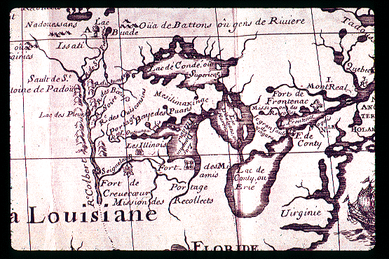 to his countrymen maps indicating the existence of more than one large body of water in the interior of North America. In 1650, the map of Frenchman Nicolas Sanson d'Abbeville was the first to note correctly the existence of all five great lakes. Sanson's map, however, clearly indicates the limits of even French knowledge. The lake's shapes are not accurate, Lakes Ontario and Erie are particularly poorly represented, and Lakes Superior and what is today known as Lake Michigan flow open- ended off the left hand edge of Sanson's map.
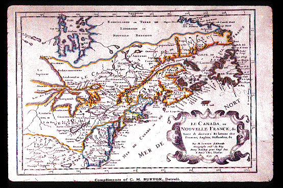
The French probed the shores of the Great Lakes throughout the seventeenth century and in 1672 a remarkably detailed map of Lake Superior, created by Jesuit Father Dablon, was printed to fill in the uncertainties shown by Sanson. Hennepin's map preceded by eleven years the even more remarkable effort of Recollect Father Louis de Hennipin. Based on the best available past maps and new information gathered by the explorers Joliet and Marquette, the maps found in Hennepin's 1683 book, Description de Louisiane are the first to show all five Great Lakes with approximately correct boundaries.
Although the work of France's best mapmakers showed continual advancement, the history of published maps in France was not one of continual advancement. In 1703, for example, Baron Lahontan published his widely read and very influential volume, Nouveaux Voyages. Although it sold well in both France and England, Nouveaux Voyages was full of misinformation. Noted map expert Louis Karpinski wrote in 1931 that Lahontan was a cartographer "for whom the real facts were only incidental or accidental." Nevertheless Lahontan's successful book did much to undo the sound information earlier published by more careful mapmakers such as Dablon and Hennepin.
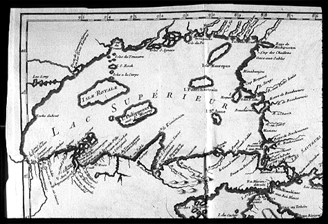 Even good maps could contain significant mistakes. In 1719 Jesuit Pierre Charelevoix was sent to survey the French colonies in America. When his Histoire et Description Generale de la Nouvelle France was published in 1744 it quickly became respected. In particular the maps drawn for the book by Nicolas Bellin were a notable improvement over all previously published work. However, in his map of Lake Superior published in the Histoire Bellin included a fictitious Isle Philippeaux which he located near Isle Royale. Perhaps because his maps were so reliable, other mapmakers copied Isle Phillipeaux onto new maps for almost a century, and in some cases embellished the mythical island with equally mythical neighbors.
The years 1755, when France and England went to war primarily over their colonial empires, 1763, when a defeated France ceded virtually all of her North American colonies to England, and 1783, when the English in turn abandoned their war against their thirteen rebellious North American colonies, all proved good years for maps. Cartographers sought to turn a profit by publishing maps to meet the European public's interest in learning more about the North American continent.
Maps of Ownership
 Although by 1683
the French had published maps that outlined the Great Lakes, what lay in
the interior of the peninsulas that would someday become Michigan was a
matter of conjecture. Although the interior region of many maps were
simply blank, some mapmakers responded to this lack of information with
speculation. For example, John Senex, a leading British cartographer of
his day, issued a map in 1719 that expanded upon the limited knowledge
the British had regarding the Appalachian mountains to create a lovely,
but mythical, chain of mountains running from northern Michigan down the
continent to Florida.
Although by 1683
the French had published maps that outlined the Great Lakes, what lay in
the interior of the peninsulas that would someday become Michigan was a
matter of conjecture. Although the interior region of many maps were
simply blank, some mapmakers responded to this lack of information with
speculation. For example, John Senex, a leading British cartographer of
his day, issued a map in 1719 that expanded upon the limited knowledge
the British had regarding the Appalachian mountains to create a lovely,
but mythical, chain of mountains running from northern Michigan down the
continent to Florida.
Slowly, however, colorful speculation gave way to more detailed knowledge. Much of this knowledge was driven by the need to accurately record property ownership. The French began this process by creating maps documenting private land claims at various colonial outposts such as Sault Ste. Marie and Detroit. French land claims, however, tended to be few in number and generally located along waterways. Until the founding of the American Republic the interior of Michigan remained unmapped.
 Unlike the French, who never
anticipated the large scale settlement of North America by Europeans,
the government of the newly formed United States of America foresaw a
future in which the wilderness would be converted into privately owned
farmland and fully settled by Americans of European ancestry. To
facilitate this process the government undertook the creation of
detailed survey maps, which would create a source of documentation for
subsequent land claims made by settlers.
Unlike the French, who never
anticipated the large scale settlement of North America by Europeans,
the government of the newly formed United States of America foresaw a
future in which the wilderness would be converted into privately owned
farmland and fully settled by Americans of European ancestry. To
facilitate this process the government undertook the creation of
detailed survey maps, which would create a source of documentation for
subsequent land claims made by settlers.
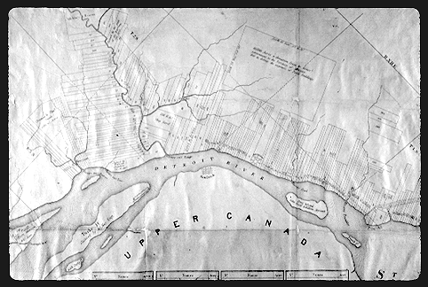
In 1815 the first federal land surveys began in Michigan Territory. In that year two fundamental lines, the original "base line" and the territory's "prime meridian" were established. The base, or east-west, line was established at 42 degrees, 26 minutes and 30 seconds north latitude, or what is today the northern boundary of the tier of counties between Wayne and Van Buren. The prime meridian, which ran north-south, was established at 84 degrees, 22 minutes, 24 seconds west longitude, which was a line drawn straight north from Defiance, Ohio. All subsequent land surveys in the state referred back to these principle coordinates.
 Surveying with
the aid of magnetic compasses and chains that measured sixty-six feet
in length, land surveyors painstakingly measured out the state. Many
preferred to work in winter when vegetation did not block their path and
the bitter cold kept away the swarms of insects that beset survey crews
in the summer. By 1840 virtually all of the lower peninsula had been
surveyed, but preliminary survey work in the upper peninsula was not
completed until 1851.
Surveying with
the aid of magnetic compasses and chains that measured sixty-six feet
in length, land surveyors painstakingly measured out the state. Many
preferred to work in winter when vegetation did not block their path and
the bitter cold kept away the swarms of insects that beset survey crews
in the summer. By 1840 virtually all of the lower peninsula had been
surveyed, but preliminary survey work in the upper peninsula was not
completed until 1851.
In 1826, when John Farmer published his first map of Michigan, only southeastern Michigan had been surveyed. But as settlers poured into the state the demand for maps made Farmer's publication a profitable one. Farmer's map was not the first of its type published of Michigan territory. A year earlier, in 1825, Orange Risdon had published a territorial map. Risdon, however, lived in New York and had employed Farmer to prepare the basic information. Farmer took what he learned from working with Risdon, improved upon Risdon's publication, and demonstrated himself more than a match to his former employer. Farmer and his son Silas would serve as the state's principal mapmakers for the rest of the nineteenth century. Generations of immigrants to Michigan plotted their course and staked their land claims based upon the Farmer map in their hand.
 Many immigrants staked their claims
by purchasing land directly from the federal government. Inevitably
however, those with means saw land speculation as a profitable form of
investment, and they would often buy up hundreds or even thousands of
particularly desirable acres with the intention of subdividing the land
and selling it at a profit. The most ambitious speculators created their
own cities.
Many immigrants staked their claims
by purchasing land directly from the federal government. Inevitably
however, those with means saw land speculation as a profitable form of
investment, and they would often buy up hundreds or even thousands of
particularly desirable acres with the intention of subdividing the land
and selling it at a profit. The most ambitious speculators created their
own cities.
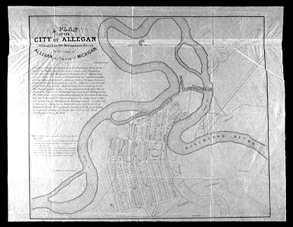
The first step for an ambitious land speculator was to draw up a plat map. On it the developer drew streets that usually did not exist, parks that consisted only of wilderness, and most importantly lots available for immediate sale. Invariably these plat maps included optimistic statements about the soon-to-be-established community. For example, the 1836 original plat map of the city of Allegan proudly states, "It is confidently believed from the great natural and acquired advantages of Allegan that it will ere long rank with the first cities of the west."
Land speculation, however, was inherently risky. In many cases the "community" failed to generate sales and the land remained wilderness. Other communities, like Allegan, did come into existence, but never prospered sufficiently to match the extravagant hopes of their founders. With a 1990 population of 4,576 Allegan remains a pleasant, rural community but even its most ardent boosters would unlikely rank it among "the first cities of the west."
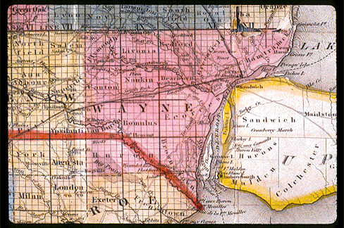
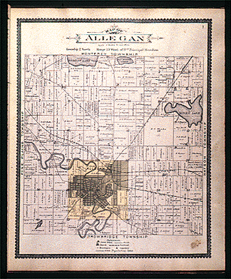
As land purchases increased, publishers realized that there was a market for maps denoting property ownership. John Farmer was among the first in the state to see this market. In 1855 he published a Map of Wayne county...Exhibiting the names of the original purchasers and the number of Acres... By the 1870's county atlases were common, with several national firms specializing in their publication. A typical example of these firm's work, a page from the Allegan County Atlas of 1895, appears here. County atlases continue to this day to be a profitable form of specialty publication.
 Business needs also led to a second form of local map
denoting information about private property, the fire insurance map. In
the 1850's fire insurance companies began to evolve from local
institutions to national firms. As they expanded their area of coverage,
fire insurance companies sought an accurate, reliable way to evaluate
the risk of fire to the buildings they were asked to insure.
Business needs also led to a second form of local map
denoting information about private property, the fire insurance map. In
the 1850's fire insurance companies began to evolve from local
institutions to national firms. As they expanded their area of coverage,
fire insurance companies sought an accurate, reliable way to evaluate
the risk of fire to the buildings they were asked to insure.
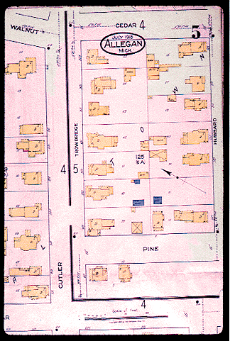
The need for fire-related information led mapmakers to begin printing highly specialized community maps. As exemplified by this map from Allegan created in 1918, these large scale, block-by-block maps noted the shape, type of construction, and other peculiar characteristics of each existing structure on the block. The maps made it possible for insurers to assess both the risk of fire in a particular building as well as the overall fire risk in a neighborhood. Of the many firms that originally printed fire insurance maps, the most successful was that founded in 1867 by D.A. Sanborn. Because of this firm's eventual dominance of the field, the phrase "Sanborn maps" has become synonymous with these types of records.
Maps of property ownership continue to serve an important purpose. County atlases are frequently published and regularly used. Virtually all records of property ownership existing today can, however, be traced back to the original land surveys conducted by the federal government between 1815 and 1851.
Transportation - Maps
Among the oldest use for maps was to aid travelers. In the state's history the most important transportation maps were first those used for navigation, second, maps that charted the spread of the railroads, and finally maps that recorded the construction of roads for automobiles.
Navigation
 One
purpose of French map making was the creation of navigational charts.
Although the general outline of the lakes was known to sailors by the
late seventeenth century, developing accurate and detailed navigational
charts that could adequately supplement the knowledge of a skilled
sailor took more than a hundred years. As late as the War of 1812 both
British and American captains experienced difficulty because they lacked
accurate charts.
One
purpose of French map making was the creation of navigational charts.
Although the general outline of the lakes was known to sailors by the
late seventeenth century, developing accurate and detailed navigational
charts that could adequately supplement the knowledge of a skilled
sailor took more than a hundred years. As late as the War of 1812 both
British and American captains experienced difficulty because they lacked
accurate charts.
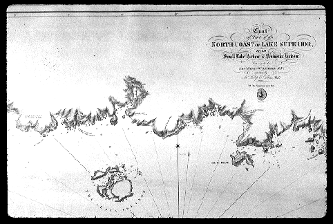
At war's end the British admiralty took steps to develop the first systematic navigational charts for the Canadian lakes. In 1816 Henry Wolsey Bayfield, then a young lieutenant in his majesty's navy, was made part of a survey party ordered to chart a portion of the lakes. Bayfield continued to participate in and later be responsible for the creation of navigational charts until he retired from the navy in 1856. His work led to creation of navigational charts for virtually all of the Great Lakes, the St. Lawrence River, and much of Canada's Atlantic shoreline. For many sites along the lakes Bayfield's charts would remain the primary point of reference until the first years of the twentieth century.
Railroads
As settlers began to move inland, away from the waters of the Great Lakes, maps showing the routes between settlements were needed. Although some maps displaying overland transportation routes were created, for example John Farmer's first map was of the government road that ran from the mouth of the Maumee River in Ohio to Detroit, most nineteenth century roads were little more than cleared paths that shifted to suit the changing whims of nature or the preferences of a particular teamster. The impermanence of such roads made it difficult if not impossible to accurately map them.
 Unlike the meandering roads built for horse
and wagon, railroad track had a permanence that well suited the mapmakers art and a market composed of travelers. In 1836 Michigan's first
railroad was opened between Toledo and Adrian. In that same year the
Michigan Central Railroad began construction westward from Detroit. As
documented in a map published for the line's stockholder's, the line
anticipated moving westward across the state's southern counties. The
Michigan Central reached New Buffalo, making it the first east-west
railroad to cross the lower peninsula, in 1849.
Unlike the meandering roads built for horse
and wagon, railroad track had a permanence that well suited the mapmakers art and a market composed of travelers. In 1836 Michigan's first
railroad was opened between Toledo and Adrian. In that same year the
Michigan Central Railroad began construction westward from Detroit. As
documented in a map published for the line's stockholder's, the line
anticipated moving westward across the state's southern counties. The
Michigan Central reached New Buffalo, making it the first east-west
railroad to cross the lower peninsula, in 1849.
Construction of the first north-south railroad line in the lower peninsula took considerably longer and created much controversy. Since any north-south line would necessarily end in a port city, discussion occurred regarding where this "northern terminus" should be located. The straits of Mackinac were an obvious choice, and was selected by the Michigan Central. Competing lines, however, preferred Ludington, based on an argument that a ferry line between that city and Manitowoc, Wisconsin would be less impeded by ice than ferries operating from Mackinac. Ultimately railroad ferrying operations were established in 1874 at Ludington and in 1881 at Mackinac.
Iron rails first came to the upper peninsula in the 1850's. In 1857 the Iron Mountain Railroad began operating between Marquette and Negaunee. During the 1870's and 1880's two competing groups built east-west railroads across the peninsula. The Detroit, Mackinac, & Marquette, opened a line between St. Ignace and Marquette in 1881 that many hoped would eventually span the upper peninsula. However because of financial difficulties additional construction was very slow. The line was absorbed in 1886 by the Duluth, South Shore & Atlantic and in this new incarnation by 1889 it became possible to ride from the Soo to either Houghton or Duluth. Eventually this "northern route" across the peninsula was absorbed by the Canadian Pacific. At the same time as the northern route was being constructed a second group of investors sought to build a line from Sault Ste. Marie to the twin cities of Minneapolis/St. Paul. The Minneapolis, St. Paul & Sault Ste. Marie Railroad, or the "Soo" line, began construction in 1884. It closely followed the shore of Lake Michigan, reaching Sault Ste. Marie in 1887.
 As railroads built
new lines across Michigan, mapmakers quickly placed the lines on their
existing maps. In 1837 Farmer included the new railroads on his state
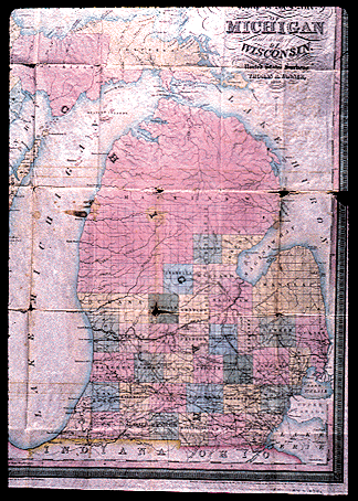
map. By 1839 mapmakers such as Tanner, whose map is displayed here,
were noting both existing and proposed rail lines. Doggett's Railroad Guide & Gazetteer, published
in 1848, appears to have printed the first map crated exclusively to
illustrate Michigan railroads. In 1857 the first map to include upper
peninsula rail lines was created by J.L. Hazard. Hazard's "map of Lake
Superior with its Rail Road & Steamboat Connection" was published by
Charles Desilver. By the early 1860's a new state railroad map was
issued almost annually by one map maker or another.
As railroads built
new lines across Michigan, mapmakers quickly placed the lines on their
existing maps. In 1837 Farmer included the new railroads on his state
map. By 1839 mapmakers such as Tanner, whose map is displayed here,
were noting both existing and proposed rail lines. Doggett's Railroad Guide & Gazetteer, published
in 1848, appears to have printed the first map crated exclusively to
illustrate Michigan railroads. In 1857 the first map to include upper
peninsula rail lines was created by J.L. Hazard. Hazard's "map of Lake
Superior with its Rail Road & Steamboat Connection" was published by
Charles Desilver. By the early 1860's a new state railroad map was
issued almost annually by one map maker or another.
In competition with commercial mapmakers, the railroad companies published maps showing the route taken by their own lines, while usually excluding the routes of their competitors. These route maps tended to grow out of maps originally issued as promotional devices to sell railroad stock. For example, the first map of the Michigan Central, which is shown here, was issued in 1855 as part of the annual report to stockholders and was clearly meant to impress upon the lines investors the wisdom of owning MCRR stock rather than attract new passengers to the line.
Like maps designed to lure investors, early railroad route maps often displayed proposed routes rather than track actually laid. Although in many cases these early railroad maps give an accurate portrayal of what was to come, company publications, as well as information given by railroad companies to commercial mapmakers such as Farmer, were as much promotional brochures as true maps. For example, two maps appeared in 1857 noting proposed rail routes to Mackinaw City, twenty-four years before the paying customer could actually ride over the track. Similarly the Flint & Pere Marquette's first map, issued in 1864, showed a route to Ludington that took ten years to actually construct.
By the late nineteenth century information about railroad routes was readily available to the public. Both from commercial maps and through company-issued route maps the public could learn how to make their "connection."
Automobile & Tourist Maps
 If
transportation maps of the nineteenth century Michigan were synonymous
with railroad routes, in the twentieth century maps documenting
transportation routes increasingly meant highway maps. The appearance of
the automobile in twentieth century Michigan revolutionized the status
of roadways. In 1900 approximately eight thousand automobiles existed in
the United States, or about one car for every 9,500 individuals. By
1910 there was one car for every 210 individuals, and by 1920 the ratio
had declined to a car for every thirteen Americans. By 1930 a car
existed for every five Americans; almost thirty million vehicles were
being driven in the United States. This astonishing increase in the
number of cars created tremendous public demand for good roads on which
to drive.
If
transportation maps of the nineteenth century Michigan were synonymous
with railroad routes, in the twentieth century maps documenting
transportation routes increasingly meant highway maps. The appearance of
the automobile in twentieth century Michigan revolutionized the status
of roadways. In 1900 approximately eight thousand automobiles existed in
the United States, or about one car for every 9,500 individuals. By
1910 there was one car for every 210 individuals, and by 1920 the ratio
had declined to a car for every thirteen Americans. By 1930 a car
existed for every five Americans; almost thirty million vehicles were
being driven in the United States. This astonishing increase in the
number of cars created tremendous public demand for good roads on which
to drive.
The Federal Highways act of 1921 established and funded America's first interconnected network of highways. The law authorized each state to designate up to seven percent of its roads as "primary." The federal government pledged to match, dollar for dollar, expenditures made to improve these primary roads. The intent of the 1921 law was to finance a network of approximately 200,000 miles of paved roads that would serve every city in America with more than 50,000 residents.
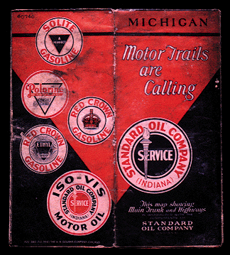
The automotive public not only demanded new roads but very quickly also began to ask for new maps that delineated paved highways. Among the most distinctive type of map to emerge to meet this demand was the gas station promotional map. For generations, motorists assumed that a road map was theirs for the asking with every fill-up. Gas station maps included not only highway information but also advertisements, the most common of which was to place on the map the location of the company's service stations. A typical example appears above, with paved roads denoted by solid red lines, "improved" gravel roads noted with dotted red lines, other roads noted in blue and the Blue "S" showing communities with Standard gas stations.
 The idea of using maps to
directly advertise commercial activities spread quickly. As highways
were constructed it seemed that every tourist attraction in Michigan had
issued a map denoting how all roads led invariably to it. Although
tourist maps proliferated with the coming of the automobile, the
concepts of linking maps and tourism was pioneered by the railroads.
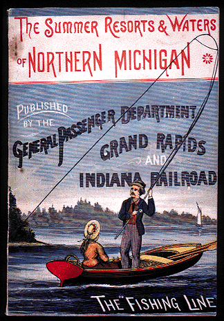
Among the first lines in the state to create this linkage was the Grand
Rapids & Indiana, which in the 1880's dubbed itself the "Fishing
Line." In a series of ever more elaborate publications, as typified by
the 1884 publication reproduced here, the GR & I extolled the many
tourist attractions along its Lake Michigan track, with an emphasis on
sporting activities. Other railroads copied the GR & I and laid the
groundwork for the far more common automotive tourist maps of the
twentieth century.
The idea of using maps to
directly advertise commercial activities spread quickly. As highways
were constructed it seemed that every tourist attraction in Michigan had
issued a map denoting how all roads led invariably to it. Although
tourist maps proliferated with the coming of the automobile, the
concepts of linking maps and tourism was pioneered by the railroads.
Among the first lines in the state to create this linkage was the Grand
Rapids & Indiana, which in the 1880's dubbed itself the "Fishing
Line." In a series of ever more elaborate publications, as typified by
the 1884 publication reproduced here, the GR & I extolled the many
tourist attractions along its Lake Michigan track, with an emphasis on
sporting activities. Other railroads copied the GR & I and laid the
groundwork for the far more common automotive tourist maps of the
twentieth century.
Since their invention in the nineteenth century, transportation maps have become a commonplace tool used in getting from here to there. Over the years, however, these maps have evolved and often become linked with various commercial enterprises, spawning a distinct genre of tourist literature.