Isabella Indian Reservation
Legacies of Isabella County's Early Indian Reservation 1855-1872
By: Hudson Keenan
When much of the public thinks of "Indian reservations" they almost invariably envision a remote, dusty location somewhere in the desert southwest. It frequently surprises people when they learn that Michigan has within its boundaries many Indian reservations. One of the earliest and most historically interesting was founded in Isabella County in 1855. Unfortunately, the early history of the Isabella County reservation is poorly documented and surrounded by considerable myth and misinformation.
We hope that by presenting Mr. Keenan's research regarding the reservation many of these myths and errors can be corrected. Should readers disagree with Mr. Keenan's facts or interpretation, we hope they will work toward documenting alternate ideas and thus help create an even richer understanding of the Isabella County reservation.
Coming of the Chippewa to Isabella County
 Just
off Mission Road north of Mt. Pleasant at the Chippewa River is a
historical site and marker. Probably many have never noticed on the west
side of the road a few hundred feet north of the bridge a small stone
memorial. A bronze tablet tells of the
council house being located at this location where the Chippewa
Indians and Government people met to do business.
Just
off Mission Road north of Mt. Pleasant at the Chippewa River is a
historical site and marker. Probably many have never noticed on the west
side of the road a few hundred feet north of the bridge a small stone
memorial. A bronze tablet tells of the
council house being located at this location where the Chippewa
Indians and Government people met to do business.
When the monument was dedicated on June 19, 1931, between two and three hundred people were present from all areas of the county. The local chapter of the D.A.R (Daughters of the American Revolution) had made this their project to erect Isabella County's first historical marker. The DAR had enlisted the State Highway Department for grading and landscape, along with the city of Mt. Pleasant for the footings. The glacial boulder itself was transported from a farm in Deerfield Township and the plaque is attached. Newspaper reports covered the event in detail. Two six-year-old boys, one from the Mt. Pleasant Schools and one from the U.S. Indian School on Harris Street, unveiled the monument draped with the Stars and Stripes. The Indian School Band provided the music for the occasion. The local paper reported that Chief Elijah Elk, mounted on a white pony and leading members of the tribe dressed in native gear, stole the show.
One might well ask the significance of this locale and why the effort to mark it as Isabella's first historical marker. Certainly, it is not a site of early man in Michigan but rather a story of an attempt to stop the decimation of native Americans by the onslaught of settlers in the mid-nineteenth century in Michigan. The success of this endeavor was flawed, not so much by the plan but by those wishing profits in lands and forests.
It is worthwhile to look briefly back in time long before settlers and treaties to see conditions in the peninsulas. Archaeologists such as W.B. Hinsdale concluded years ago that the total number of native Americans in Michigan was not great, perhaps only 15,000 in the entire state. The nature of their existence, primarily hunting, fishing, and gathering kept the relatively small groups or bands on the move. This type of existence carried over into the nineteenth century but this pattern of life was not compatible with the wave of settlers coming into Michigan.
An interesting example of the Indian movement is in our earliest written account in central Michigan. Jesuit Father Henri Nouvel recorded his experiences in a journal he kept. Fr. Nouvel journeyed with the Chippewas on a hunting and fishing expedition through what is now Isabella County on the Chippewa River in the winter of 1675-76. Apparently, it was the custom for the Indians to move into the Saginaw valley in this season to escape the more severe winters of the upper lakes.
Reverend George Bradley, over a century and a half later, left an account in which he mentions the Chippewas, more particularity the band of Swan Creek and Black River, moving in what is now Oakland County. Rev. Bradley referred to their condition as degraded. All of the things we have heard-disappearance of hunting and fishing lands with settlement, disease, and alcoholism-were taking their toll.
The Methodist Episcopal Church Missionary Society started its efforts with this group in 1841. With increasing settlement in the area, it was deemed best to establish a mission in western Lapeer County in 1842. At this location, they were isolated for a time and the band grew, eventually numbering about 300 individuals. They called this settlement Ne-bi-sing, a name they would later bring with them to Isabella county for a church and school southeast of present day Rosebush. By the year 1853 the tide of settlement was crowding the Lapeer area, and once more, conflicts both social and cultural were being felt by the band.
Bradley recalled it was during this time that
"It was agitated some about getting one large reservation for the Indians in the Saginaw Valley for a home."
 The
various missionaries must have discussed the problem, for a letter was
written in 1854 by two of them, Reverends George Smith and P.O. Johnson,
to the corresponding secretary of the Missionary Society of the
Methodist Episcopal Church, Rev. J.P. Durbin.
They urged Durbin to petition the government to withdraw Isabella
county lands from sale and set them aside for use and eventual purchase
by the Indians.
The
various missionaries must have discussed the problem, for a letter was
written in 1854 by two of them, Reverends George Smith and P.O. Johnson,
to the corresponding secretary of the Missionary Society of the
Methodist Episcopal Church, Rev. J.P. Durbin.
They urged Durbin to petition the government to withdraw Isabella
county lands from sale and set them aside for use and eventual purchase
by the Indians.
Reverend Durbin then wrote the Hon. George Manypenny, U.S. Commissioner of Indian Affairs, in December of 1854. In his letter, he stated that they were after an area where all Indians of the Lower Peninsula of Michigan could be brought together. He further stated; "In regard to the Indians in Michigan, public opinion seems to be in favor of their remaining in the State with a view to their becoming permanent cultivators of the soil." Probably not stated but obvious to all, it would help the Methodist Mission to focus their resources and efforts. In addition, Commissioner George Manypenny held the belief that the best chance for blending the onslaught of white settlers looking for land and various Indian tribes was through the efforts of missionary groups.
The upshot of this was the treaty of August 2, 1855, signed in Detroit between the Chippewa Indian band of Swan Creek and Black River and the United States Government. The treaty itself had seven articles and many details governing everything from stipends to land ownership. (View full text of the treaty).
 In simplest terms, Federal lands in an area of six
townships of Isabella County were withdrawn from sale in the land office
and set aside for a period of time. Individual Indians could select
acreage and stake a claim, eventually receiving a patent following
guidelines of the treaty.
In simplest terms, Federal lands in an area of six
townships of Isabella County were withdrawn from sale in the land office
and set aside for a period of time. Individual Indians could select
acreage and stake a claim, eventually receiving a patent following
guidelines of the treaty.
Even at this early date, a number of parcels of land had already passed into private hands. One example being acreage held by David Ward, a prominent pioneer lumberman, who originally owned much of the land in present day Mt. Pleasant. Another example was the designated Swamp Land Forties granted to the State of Michigan and not affected by the treaty. The vast majority of lands were still in Federal ownership and on these lands sale was halted and held for Indians to avail themselves under the treaty. The area included the north half of what are now Union, Chippewa, all of Deerfield, Denver, Wise, Isabella and Nottawa Townships in Isabella County.
Lists were made of eligible native Americans. The eligible had five years to make their land selection. After selecting, a certificate was issued and in ten years they were to receive a patent for the property. In the 1864 treaty this was changed with the "competent" and "those not so competent" judgment on each individual before the patent would be issued. Those judged competent could receive a regular patent and those not so competent would have the Government Indian Agent oversee any sale.
A gentleman named Richard Smith was to oversee this program as the new Indian Agent. I.A. Fancher in his book, Isabella County, said Mr. Smith was strongly in favor of limiting the number of individuals designated as competent. The idea was to encourage Indians to stay on the land and also to help assure that the property would not be sold to speculators at a fraction of its true value. On his way to Michigan to take his position as Indian Agent, his vessel sank in Lake Huron during a storm and he was drowned. Mr. Smith's passing and other legal complications resulted in a backlog of certificates and few patents being issued.
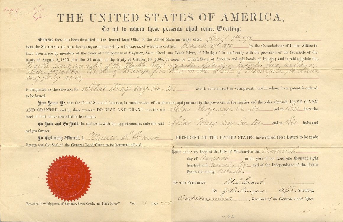 Eventually in 1872, hundreds of Government Patents
were issued to native Americans in accordance with the treaties. About
the same time, the local Indian Agent's office was disbanded and many of
the functions taken over by the county government, essentially
the reservation and services were finished at this time. Many
Indians sold their land soon after receiving a patent. Speculators in
lands and forests arrived in great numbers and in a few years, any
resemblance of an Indian Reservation had vanished.
Eventually in 1872, hundreds of Government Patents
were issued to native Americans in accordance with the treaties. About
the same time, the local Indian Agent's office was disbanded and many of
the functions taken over by the county government, essentially
the reservation and services were finished at this time. Many
Indians sold their land soon after receiving a patent. Speculators in
lands and forests arrived in great numbers and in a few years, any
resemblance of an Indian Reservation had vanished.
We will have more to say about this but in retrospect, the 1855 to 1865 period represents the original Indian Reservation in Isabella County. It would be over seventy years later that the reservation program would develop east of Mt. Pleasant in Chippewa Township. Features of the 1855 treaty, the support of most education, the mill, the blacksmith as well as stipends all ended in 1865.
The Reservation, created in Isabella County in 1855, would be unique. It essentially removed from general sale the remaining available lands in an area equal to six townships in Isabella County. These remaining lands were held for the exclusive use of the Indians to take patents for a period of time. No provisions for tribal organization were included and no tribal lands were set aside in the treaty.
The Indians were urged to come and settle in this area and take title to individual parcels. The Methodist Episcopal Church spearheaded the effort in getting the treaty and establishing the settlement. The government provided aid for approximately ten years with a blacksmith, mill, education and stipends. It provided for an Indian Agent to oversee the operation.
After 1872 when the last Indian patents were issued, the six township area was once again open and any remaining lands could be patented as any other lands in Michigan. As for the Indians, they were able to sell parcels of lands in the same way as any other landowner could after receiving a title.
With this brief background, we next follow the developments after the treaty of 1855. We will cite some happenings and do a geographical tour of places in the sparsely settled wilderness lands of Isabella County as provisions of the agreement were put in place.
Indian Mills on the Chippewa River
 At
the time of the treaty, no specific mill site was selected, but one was
soon chosen along the section line where present day Mission Road
crosses the Chippewa. The location is a natural one as it closely marks
the border between the glacial lake plain
to the east and the hilly moraines to the west.
At
the time of the treaty, no specific mill site was selected, but one was
soon chosen along the section line where present day Mission Road
crosses the Chippewa. The location is a natural one as it closely marks
the border between the glacial lake plain
to the east and the hilly moraines to the west.
Work went forth on the mill site in the summer and fall of 1857. A Mr. Penmant was engaged to build the mill. All the mill machinery had to be brought up the river. A deck was made between two large canoes to support the equipment. Consider the labor and time to pole up the river all the needed items. The combination gristmill and sawmill were finished in the fall but not inspected and accepted until the following spring.
Charles Taylor was an early settler in Chippewa Township. He wrote a series of articles on his memories of early Isabella County, which were preserved in a former Mt. Pleasant newspaper, The Northwestern Tribune. Writing in 1888, he recalled those opening days at Indian Mills in the spring of 1858.
"The people of Chippewa (a rather large group of settlers had arrived in fall of 1855) turned out and cut a road through the forest to the mills, and as soon as the grist mill was ready for work, a number of us went up with two wagons, two yoke of cattle to each wagon, it being the first time the writer had been there. We had to leave our teams on this side of the river (south side) and carry our grist over the timbers of the bridge there being nothing there but the frame of the bridge."
The sawmill part of the mill operation was now operative and some planks had been cut. While waiting for the grist to be made into flour Taylor continues:
"We called for volunteers to carry plank on the bridge and we soon made it so that we got over it all right. By night we got home from our first trip to the mill, it being only about seven miles, yet consumed two days."
Without doubt this was the first bridge over the Chippewa River and would be used by many in those early years. Taylor adds: "The Indian Mills was a great help to all both Indians and whites." A.F. Albright operated the government mill as superintendent and employed two assistants, Indians Henry Strong and James Williams.
Twelve years later another similar event was recalled by Fred Kent of northwest Isabella County's Sherman Township in a newspaper article in The Northwestern Tribune on April 27, 1888:
"In the summer of 1870 my brother Oscar and I made a trip to Isabella City (Indian Mills) with an ox team and grist of wheat. The distance was 20 miles but by getting an early start and making free use of the persuader, we reached the city before sun- down. After leaving our grist at the mill we drove down the river flats, fed the oxen and slept under the wagon until morning."
Kent's memories were at the end of the Indian Mills era. The mill burned later that year and the dam also washed out. With the coming of the lumber era and subsequent log drives, one wonders if the demise of the site was hastened by more than nature.
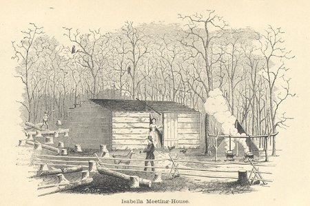
The mill site was just west of the present Mission Road bridge and just north of the river. The present day marker, referred to earlier, designates the site of the Council House built in 1857. The house was described as a two-story affair. The first floor held the Government Office and a storage room. The second floor was the council room where business between the Indians and the government was transacted. Charles Taylor remembers attending a "quarterly meeting" in 1861 in the council room. The Council House was still standing according to the plat of 1879 but its functions had largely passed. Many trading activities between Indians, fur traders, farmers and peddlers took place in this locale just before and during the Civil War.
I.A. Fancher's book written in 1911, Past and Present of Isabella County, contains considerable detail on the County at this time. Special mention is made of young men departing for the Civil War from Indian Mills:
"The oxen were hitched to the old double wagon, the family placed thereon and a start was made to the Indian Mills where the enlisted were to meet and from there were to go down the Chippewa River on a raft provided for their journey."
Many journeyed all day to arrive for the departure the next morning. It was recalled that family members and spectators lined the banks as the raft laden with the recruits and their baggage swung out into the river. Fancher states that a total of 67 Indians and 53 whites were enlisted during the war from the county. At the time of the Civil War the county's population numbered about 1,500 persons nearly equally divided numbers between whites and Indians.
Moving away from the river and mill, another scene would have greeted the visitor in those days. Beyond the Council House stood the blacksmith shop. The clang of a hammer and a wisp of smoke were part of the sights and sounds. A group of Indians and whites were always present getting things repaired and metal work done. It was said that this was the only place for two or three days travel in any direction where you could obtain this type of service in the late eighteen fifties.
The blacksmith shop was built like a blockhouse with a four-sided roof rising to a central peak. It had vertical siding and a large double door in the front. Living quarters were provided for the blacksmith above the shop.
Benjamin Cushway was the first blacksmith in 1858. Marcus Girnell had the job in the early sixties. Cushway, from all accounts, was most fluent in the Indian tongues. He was first a blacksmith for the Indians in 1834 at the old Fort Saginaw site and was known throughout the valley. He was at Indian Mills for a short time but his family stayed in Saginaw. Cushway felt the Indian Agent, A.W. Fitch unfairly treated the Indians, and the latter soon dismissed him.
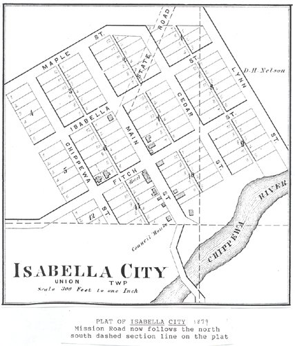
Indian Agent A.W. Fitch was the first of several to hold the post. Private enterprise was not far behind the government activity at Indian Mills. Agent Fitch was more than just the Indian Agent, both he and his brother-in-law, F.C. Babbitt, saw economic possibilities. With government stipends to the Indians, need for supplies, mill and blacksmith shop in place there was certainly a future at this location. Thus came about Isabella City.
When F.C. Babbitt passed away, included among other things in his obituary was this statement: "He brought with him to this, the new country, a considerable amount of means which by the closest application to business, wise economy and untiring industry he has increased to a very fine estate." Let us follow how brothers-in-law F.C. and A.W. progressed with Isabella City.
A.W. Fitch purchased land adjacent to Indian Mills in 1859. He and Babbitt platted Isabella city in 1861. The land purchased for the plat was designated "swamp land" and thus part of a large grant of land the State of Michigan had received from the Federal Government some years before. "Swamp Land Forties" were forty acre plats where swamps and "overflowed" lands existed. The determination of these forties was made from surveyor field notes in the 1830's in this case.
The legacy of this plat remains with us. Drive the gravel road past the historical monument to the northwest. This was Main Street in Isabella City. In the author's opinion, it was laid out on an angle to be parallel to the Government buildings. Most likely the Government buildings were on an angle because the mill was at right angles to the Chippewa River. Follow the road (Main Street) on to the northwest where it curves to the right past Memorial Gardens Cemetery. In the 1870's, it became part of the State Road to Clare from Mt. Pleasant, the curve was added at this time.
Today it is Craig Hill Road, a name derived from the Sarah Craig farm near the top of the hill. Craig Hill became a popular landmark known to travelers and early motorists, being the steepest hill in the area along with Mt. Pleasant's Island Park hill. It would be 1930 when the new concrete highway was finished to Clare. The route of US 27 (Mission Road today) was straightened and the old route through Isabella City was abandoned.
While on the subject of roads note how present day River Road curves and connects with Mission Road on an angle. The angled portion of the road was originally Fitch Street, running from present Country Club in a northeasterly direction and is at right angles to Main Street, now Craig Hill Road. Now that we have the streets oriented, let us look at Isabella City at the time of the Civil War. We are fortunate that a visitor recorded an impression of Isabella City that appeared in the Detroit Advertiser and Tribune on February 9, 1863.
"City indeed---so thought we--- for after the visitor has looked at a saw and grist mill, council house, store, tavern, wagon and blacksmith shops, and a half dozen dwelling houses (all frame buildings), he is expected to supply from his fertile brain, everything else to meet his own idea of a genuine city. It is however the most important point in the county and consists almost entirely of pale faces. On the reservation there are said to be about fifty whites including children."
On the main corner of Isabella City (now Craig Hill at River) stood a large wooden hotel and tavern built by W.H. Nelson starting in 1857 and apparently growing several times by additions. Today this site is the southwest corner of the intersection in front of the dwellings overlooking the country club. The hotel remained on the corner until May of 1895 when it burned. The Enterprise newspaper in Mt. Pleasant ran a story of its demise with this comment: "A few of our older residents can remember when this hotel was in flourishing condition as any hotel in the city when Mt. Pleasant was not in existence."
Nearby, the F.C. Babbitt Mercantile establishment was located. This started as a room in the Babbitt home where a stock of flour, tea, tobacco, and coffee was kept as well as other household necessities.
Charles Taylor remembers the store: "The firm did a large business carrying the whole Indian trade for some time. The Indians had large quantities of furs, besides their annual pay, to barter for goods. They also made a home market for some time, for they were not great producers but great on the chase and the woods were nearly full of wild animals."
Just getting the goods to Isabella City was difficult, especially in late winter and early spring when the prices inched up, which was related in this comment by Taylor: "When the roads were bad sometimes prices got very high, especially so in war times, when flour was $22 a barrel, salt $11, tea $2.25 per pound, and calico fifty cents a yard, and with everything else at about the same exorbitant prices."
At this early date the Indians would come and stand in the combination store and home. F.C.'s spouse, Abigail Babbitt, running her home, fascinated them. Several references mention this and explain that she became Wasash-com-mo-quay, "the woman who brings light". Apparently Abigail was most courteous and it was reported common to have as many as six visitors at one time while she was doing household chores.
Babbitt's business continued to grow and within a year or so he had constructed a store separating the business from his home. In April 1861, a U.S. Post Office was established in his store at Isabella City.
Another facet in the trade carried on during the period was the whiskey sold by Babbitt in his store and Nelson in his tavern. At least four writers mention in early accounts liquor problems at Indian Mills. Fred Kent tells of being aroused in the middle of the night by a loud boisterous group while sleeping in his wagon on the flats, not far from the bridge. When government payments were made or furs purchased, great amounts of money and profit moved in the direction of these early establishments at the expense of the Indians.
Getting supplies and freight to Indian Mills and Isabella City was no easy matter. Freight was mainly moved up the river or on a seasonal trail along the north side of the river from Midland. Jim Hinman, one of the Indians who came into the area because of the treaty of 1855, was the "boss poler" bringing freight from Saginaw and Midland. Of all the cargo poled up the Chippewa, perhaps the most unusual, was the first piano in Isabella County. F.C. had it brought up lashed between two large canoes for the Babbitt's daughter, Nellie.
In 1864, hotel proprietor D.H. Nelson, W.H. Nelson's son, returned from the Civil War. He soon married Babbitt's daughter, Nellie, and joined his father-in-law in business. At this time, two things changed quickly affecting their business. First, the terms of the Treaty of 1855 with its stipends and subsidies for the mill and blacksmith shop were to end. Second, the voters had accepted David Ward's proposal for a new county seat several years before. A wood frame courthouse was now on the high ground up the river a mile or so in a place Ward named Mt. Pleasant.
So in 1865 Babbitt and Nelson moved their business to the new plat of Mt. Pleasant locating on the southwest corner of Main and Broadway streets where the Firstbank is now situated. After Babbitt's death in 1876 Nelson entered the fields of banking and real estate. Village president in 1886, he sold the village seven acres for a park in 1890 for $1000. The deed required the park to be named Nelson Park.
One can easily see that by 1864 the die was already cast. Less than ten years after the start of Indian Mills and Isabella City, the exodus had commenced. Major James Long, Civil War veteran and last local Indian Agent came to the area and platted the village of Longwood south of the river from Indian Mills in 1871. It never made it; only the Longwood Country School retained the name. He closed his store and joined the exodus to Mt. Pleasant in 1874 soon building the St. James Hotel on the site of the present commercial block at Broadway and University.
Isabella City became a miscellaneous collection of frame buildings, its main purpose was ended. The mill burned and the dam was no longer in place by 1870. The author noted references to "Dogtown" over 100 years ago in the local paper, a name that has prevailed far longer than Indian Mills or Isabella City.
Indian Schools and Churches
Education was another factor in the Indian treaty of 1855. Within the six townships set aside for Indian settlement, schools were scheduled to be built, equipped, and staffed by the U.S. Government. All this was to take place for the same ten-year period as the stipends and facilities at Indian Mills.
Work commenced on this portion of the project when I.E. Arnold was awarded the contract to build schools in 1857. Charles Taylor, pioneer resident, tells of his part in the project during the spring and summer of 1858. Soon after the sawmill was completed, he was hired as a teamster. He drove horses pulling logs to the mill and then lumber to the various school sites. Taylor remarked that he was "happy to get work to keep flour in the flour barrel and buy other necessities."
Each school was a one room affair with three room quarters for the teacher attached. A cookstove was part of the equipment in each building.
The location of the schools is significant for it tells us in general where the Indians took up lands. They never began to settle on all the lands in the six townships set aside in the treaty.
United States Government schools were located at present day Bamber Road at Mission Creek in Union township. In what is now Isabella Township, schools were at Jordan and Isabella, Weidman and Isabella and Jordan and Lincoln roads. One school was located in what is now Nottawa Township. Its location in the eastern portion of the township is not known, because it burned in 1864. Taking all this together it would appear the population center for the Indian settlers would be in southern Isabella Township.
In the winter of 1863, about 100 children attended the various schools according to the Detroit Advertiser and Tribune. Their reporter visited one of these schools and observed the Indian children. "They learn to read, write and spell in English and are a little familiar with arithmetic and geography." The reporter noted that they were able to pronounce English words with little difficulty, however speaking the language proved more difficult. This is not surprising as English was not used at home and speaking the language requires practice. "Vocal music however is their great attraction. They love it dearly and therefore make great proficiency in the art." Mrs. Cass Mosher would recall the same thing 67 years later as she reflected on teaching in the Indian Schools as a young woman.
A teacher lived at each school in the rooms provided. Each teacher received a salary of $400.00 per year which was considered good but as the reporter reflected: "Not any too much when we consider the personal sacrifices they were forced to make."
Apparently not all the schools were operated through the entire period but from the readings, the writer has examined two schools that stand out. One was at Bamber Road, adjacent to Mission Creek, and the other at Ne-bi-sing, corner of Weidman and Isabella Roads, southeast of Rosebush. Both had missionary facilities in addition to educational activities focused on the sites.
 I.E.
Arnold was contracted by the Methodist Episcopal Missionary Society to
build two churches on the Isabella Reservation in 1860. The Church had
disposed of their holdings in Lapeer County as the Indians had now moved
to Isabella County. Moneys from
the sale were used to erect these new facilities without additional
cost to the Society.
I.E.
Arnold was contracted by the Methodist Episcopal Missionary Society to
build two churches on the Isabella Reservation in 1860. The Church had
disposed of their holdings in Lapeer County as the Indians had now moved
to Isabella County. Moneys from
the sale were used to erect these new facilities without additional
cost to the Society.
Mr. Arnold constructed one of these churches on the northeast corner of present day River and Lincoln Roads. Unfortunately, services were held there but five months when fire consumed the structure. Church services were then conducted in the government school about one-half mile southeast on what is now called Bamber Road. Later in the Treaty of 1864 the government gave the Methodist Missionary Society this school and money to operate a "school farm" later called the Bradley Mission after the death of Reverend Bradley. In about ten years funds ceased and the property was sold. This was perhaps the first vocational program in the county. Nearby Mission Creek derives its name from the Methodist Missionary Society work among the Indians at this local.
In 1893 The United States Indian Industrial School was established and encompasses the same general land area but was not related to the Mission or its activities. The U.S. Indian School lasted for forty years until 1933 when the facilities were taken over by the State of Michigan for Mental Health purposes. The story of this school is another topic entirely separate from the treaty of 1855.
Returning to I.E. Arnold, he constructed his second church for the Society southeast of present day Rosebush. The Detroit Advertiser and Tribune reporter visited this site in February 1863. In a column next to one reporting on the Army of the Potomac in the Civil War the activities of the missionaries with the Indians in Isabella county were reported.
"The Methodist Episcopal Church has occupied the ground from the beginning. Religious services are held in the school houses except at Ne-bi-sing where a large edifice has been erected for their use."
This church was located on the southwest corner of what are now Isabella and Weidman roads. The reporter continued the account: "We had the pleasure of attending two of their meetings. They sing with will and the truths are communicated to them through an interpreter, although many can speak English quite well. This process is a tedious one, and very slow one too."
The minister was E.D. Young who served from the 1840's and had been in the ministry in the Lapeer area. He, along with George Bradley who was the first presiding elder, was the local leader of the Church. Young could converse in Chippewa but did not attempt to preach to the congregation in their native tongue. He told the writer for the Tribune that there were 200 who profess religion on the reservation.
The church like Indian Mills and the rest of the reservation era would end quickly. A dozen years later, settler Thomas Carrol would convert the Church at Ne-bi-sing to a barn. Still later, the school across the street would disappear as well. Today, standing on this corner, one has no inkling of past history as fields and undulating hills are the scene one views.
In mentioning the religious activity at the time of the 1855 treaty we would be remiss if we didn't remark of the work of Rev. G.U. Meissler of the Lutheran faith. His mission was located on the site of the present day Embers Restaurant in Mt. Pleasant and is the reason for Mission Street getting its name. How the Lutheran Mission came to the area is interesting in itself. The Mission started north of St. Louis Michigan in Bethany Township. In the 1850's, Rev. Meissler had achieved a measure of success in promoting the Christian religion among the Indians along the Pine River. With the treaty of 1855 completed, the Indians in his area as well as in other locations were encouraged to come to Isabella County and take up lands.
Rev. Meissler, seeing and feeling the effects of these happenings, deemed it necessary in 1861 to move near the reservation to continue his missionary activities. The south boundary of the reservation lands was present day High Street in Mt. Pleasant. Indian Mills was two miles directly north along the section line from present day Mission and High Streets. Rev. Meissler selected the nearest parcel of non-Indian land from this center of activity for his mission. The hundred and sixty acres or quarter section for the Mission is between the present High and Preston Streets and east of Mission extending to Crapo Street.
The corner of Mission and High was very swampy in those days so the Mission House was located on the south end of the property at Preston and Mission where the Embers is now situated.
Meissler, in addition to his missionary work, was a teacher in the U.S. Government Indian School at Isabella and Jordan road for several years. As time went along he suffered from increasingly poor health. Moreover declining attendance in the mission with completion of treaty obligations resulted in a re-evaluation of the program. In 1869 the Lutheran Synod was obliged to close the doors of the mission. The original meeting house was modified into a home and the quarter section was rented for awhile before being sold. On April 6, 1918, the original building burned and even at that time its initial purpose was remembered by "Just the oldest residents" according to an article in the Isabella Enterprise.
Examples on the landscape that remain from the early reservation days are four cemeteries. The four were started as a direct result of the formation of the Isabella Reservation.
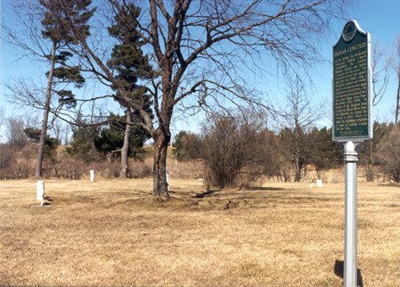 Located on Bamber Road
at Mission Creek is a cemetery site marked with an official State
Historical Marker entitled simply "Indian Cemetery". The monument
details some of the provisions of the Treaty of 1855 in addition calling
attention to the burial
site of Shawshawawnabeece who was one of the signers of the treaty.
West of the cemetery stood one of the five government schools, the
Bradley School which was previously mentioned.
Located on Bamber Road
at Mission Creek is a cemetery site marked with an official State
Historical Marker entitled simply "Indian Cemetery". The monument
details some of the provisions of the Treaty of 1855 in addition calling
attention to the burial
site of Shawshawawnabeece who was one of the signers of the treaty.
West of the cemetery stood one of the five government schools, the
Bradley School which was previously mentioned.
Yet another Indian Cemetery is just north of Base Line Road at the US 27 overpass on the west side near the present day Isabella County Fairgrounds. A third cemetery, known as the Bissing Cemetery, is on the east side of Isabella Road just north of Rosebush Road also in Isabella Township. It occupies a sandy ridge, a beach feature of ancient Glacial Lake Saginaw where waves, winds and sands formed the ridge some 13,000 years ago during the last ice age.
Redman cemetery is the western most cemetery and is located in Nottawa Township along Denver Road west of Vandecar Road. The small plot, about an acre in size, is just a half mile west of the former home of Chief Nottawa for whom the township was named. An interesting reference to this location was provided in the remembrances of Levi Van Decar (Vandecar Road namesake) written in 1884. He tells of a burial in Redman Cemetery in which he was asked to furnish the boards for the coffin from his sawmill.
 A young Indian
family had met tragedy as the wife after a lingering illness was taken
by "consumption." The father built the coffin for his spouse from the
boards provided by Mr. Van Decar. Van Decar recalled watching as the
husband loaded the coffin
in a wagon pulled by oxen. One of the children rode on one of the
oxen while the other road on the coffin as they moved slowly away to the
cemetery some two miles distant. Undoubtedly a scene of this type
occurred many times in those early days of
settlement in the 1860's.
A young Indian
family had met tragedy as the wife after a lingering illness was taken
by "consumption." The father built the coffin for his spouse from the
boards provided by Mr. Van Decar. Van Decar recalled watching as the
husband loaded the coffin
in a wagon pulled by oxen. One of the children rode on one of the
oxen while the other road on the coffin as they moved slowly away to the
cemetery some two miles distant. Undoubtedly a scene of this type
occurred many times in those early days of
settlement in the 1860's.
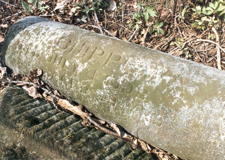
In each of these cemeteries a few graves are marked with headstones but a far greater number of interments exist without any marking. Long after reservation days, burials were made in these locations. Depressions in the ground suggest grave sites in some instances. The scattering of violets and lily of the valley remind one of the generations laid to rest in these cemeteries so many years ago. In the last few years, the importance of these cemeteries to Indian heritage and culture has been recognized and efforts made to preserve the grounds and document the interments.
Land, Lumber and Money
Realistically, to merge a culture in ten years into a white settlers' culture and a business world of money, was beyond any hope of success. Also, keep in mind the cultural blending was mostly one way. Little of the Indian ways were transferred to the settlers.
Many writers, past and present, have commented on the shortcomings of settlers and the United States Governments in dealing with Indians. I wish to direct attention to comments made by a settler, a lumberman, a missionary and an Indian Chief who were involved in the reservation during the decade or so of operation in Isabella County.
Mrs. Cass Mosher was a teacher on the Reservation and the daughter of A.F. Albright who was in charge of the mill at Indian Mills. She lived well into her nineties and was interviewed a number of times in the 1930's by reporters from the Isabella County Times News.
Mrs. Mosher in reflecting remembered a certain amount of jealousy over the Indians' assistance and lands they were able to acquire and keep under the treaty. "The white settlers crowded the Indians on every side. Efforts to reduce government assistance and put the Indian on his own as soon as the treaty conditions were completed were pushed. The settlement of Indians largely sold out and moved elsewhere in a few years." Isabella County was full of settlers coming from the east and Canada looking for land in the 1870's and 1880's.
The market for standing timber and the lumber boom in the Saginaw Valley in the 1870's created another pressure on Indian Lands. It served to detract from the goals set forth in the original treaty. Third parties would put up money and send locals out to purchase timber rights on lands before the Indians had patents from the government. Frederick Hall of Ionia, H.W. Sage of Bay City and Arthur Hill of Saginaw were some of the well known personages who worked at schemes to acquire timber lands.
 One of the best documented
cases of subterfuge involves lumberman Arthur Hill who bragged in later
years of how he was able to get the inside track on Indian Land patents
to enable him to acquire timber stands. A Mt. Pleasant attorney, John
Leaton, knew
Arthur Hill from working as a lawyer in Saginaw before coming to Mt.
Pleasant in 1871. Leaton was the key to the success of the scheme that
was well documented.
One of the best documented
cases of subterfuge involves lumberman Arthur Hill who bragged in later
years of how he was able to get the inside track on Indian Land patents
to enable him to acquire timber stands. A Mt. Pleasant attorney, John
Leaton, knew
Arthur Hill from working as a lawyer in Saginaw before coming to Mt.
Pleasant in 1871. Leaton was the key to the success of the scheme that
was well documented.
In January 1872, George Betts and John Knox came to Isabella City as representatives of the U.S. government Department of Indian Affairs. The purpose of the visit was to take selections from the Indians on lands available according to the treaty of 1864. This was done at the Indian Council House in Isabella City, the entire process taking seven days. The two recorded on plats and forms the names and selections of lands by native Americans. The materials were then to be returned to the Indian Affairs Office and patents issued. Hill and Leaton were present in Isabella City during the entire proceedings.
On the 17th of January, the two government agents finished their business and left for Detroit via Clare, as this was the closest railroad. When the stage arrived, the last train for the day had already left so they spent the night at the Sterns Hotel in Clare. They left the trunk containing the plats and selection at the depot. Leaton and Hill took a cutter to Clare and quickly noted the trunk at the depot. During the night at another hotel they had the trunk brought to their room where they succeeded in breaking it open and copied all the information on the week's business at Isabella City. The tampering was noted and Hill and Leaton were prosecuted in April 1872 in a case which was eventually dismissed.
In the History of Saginaw County by Mills (1918), details are given on how they next sent land lookers to find the best timbered forties on the lists. The account goes on to say: "Then the shrewd lawyer (Leaton) with this information and the official list of reserves, checked up with it, did the rest. He knew many of the Indians personally, and it was not a difficult matter to get them "feeling good", and then by offering them the necessities of savage life they craved, to induce them to sign away their timber rights."
Leaton went on to be village president in Mt. Pleasant and along with his partner, W.N. Brown, owned 30,000 acres of valuable forest lands in Isabella County. Arthur Hill became one of Saginaw's leading personages and today a Saginaw city high school bears his name.
Henry Sage of New York, owner of one of the biggest sawmills on the river in Bay City, had a large holding of timber in Isabella County. In the book Biography of A Businessman, Henry Sage, the author, Goodstein, states the following:
 "In 1871 Sage was
lumbering on Indian Lands in the Isabella Reservation in Michigan, lands
which had not yet been patented." A special agent from the government
was sent some years later to investigate frauds perpetrated on the
Isabella Indian Reservation.
Among other things, he stated the various parties, one of which was
Sage, paid a "mere tithe" of the actual value of the timber. According
to author Goodstein it was I.E. Arnold of Mt. Pleasant who was Sage's
"man on the scene, selecting and purchasing
timber rights to about 250 forty acre parcels, near 17 square miles
of land within the Reservation. He further stated Arnold worked with
Indian Agent Major Long in this endeavor."
"In 1871 Sage was
lumbering on Indian Lands in the Isabella Reservation in Michigan, lands
which had not yet been patented." A special agent from the government
was sent some years later to investigate frauds perpetrated on the
Isabella Indian Reservation.
Among other things, he stated the various parties, one of which was
Sage, paid a "mere tithe" of the actual value of the timber. According
to author Goodstein it was I.E. Arnold of Mt. Pleasant who was Sage's
"man on the scene, selecting and purchasing
timber rights to about 250 forty acre parcels, near 17 square miles
of land within the Reservation. He further stated Arnold worked with
Indian Agent Major Long in this endeavor."
The Bay City Herald in an October 1872 article, referred to the goings on as the "Isabella Land Ring" and mentioned the Rusts, Jerome and Company as another group that had been active for several years to cut timber and or acquire land by unscrupulous means.
Indians were many times tricked out of lands because they did not understand the land ownership system or the financial value the timber held for them. Yet there were a small few who did understand and sold out, pocketed the money, and moved on.
Reverend George Bradley of the Methodist Mission commented in his 1870 journal on the central problem of reservation failures. "The love of money has infused others to act for their own employment even at the destruction of the Indians and no measure was considered too unjust or fraudulent to engage in to accomplish their aims. This leaves the poor Indians in doubt as to who are their friends."
Bradley went on to say that the general feeling which prevails in all Christian organizations, that it does little good to expend more money towards the Indians as long as present policy prevails. This would be part of the thinking that would lead to large blocks of land being set aside for tribal use in the western United States.
Reverend George Bradley was appointed the Indian Agent in early 1871. He went to New York City in April to receive his instructions on his official duties. While there he fell dead on the street. One wonders what differences might have occurred in those last days when the land patents were issued if he had been present. The same could have been said of Agent Richard Smith mentioned earlier who drowned in a Lake Huron storm a few years before Bradley's death. Both of these men were acknowledged guardians of Indian rights.
Bradley Gills, professor of History at Grand Valley State University, researching the archives of the Commissioner of Indiana Affairs in Washington D.C. recently located a report on Indian land patents and fraudulent activities on the Isabella Reservation.
In 1877 US Commissioner of Indian Affairs, E.A. Hoyt directed Special Agent E.J. Brooks to come to Mt. Pleasant, Michigan and investigate first hand the reported wrong doings. Agent Brooks report to Commissioner Hoyt is most revealing. It is doubtful it ever saw the light of day again after arriving on the Commissioners desk.
Special Agent Brooks was not wanted in Mt. Pleasant by individuals who had high political connections. They acted quickly after his arrival. Here is an excerpt from Agent Brook's Report;
------"It is proper for one to state at the outset that, owing to my recall as per your telegram of October 20th, 1877, I was unable to make the searching examination into the matter that the case deserved, and the many facts which I learned with regard to this and former schedules and the outrageous frauds connected therewith, led me to desire.
I arrived at Mount Pleasant within the reservation at about 4 o'clock P.M., October 23, 1877, and immediately commenced work. At about 7 o'clock I received your telegram directing my immediate return, having prior to its receipt, arranged to hold a council with the Indians on the following day, and being satisfied from the facts in my possession, that by so doing I could make such a report in the matter as to enable the Department to act"------
During this day or sor prior to his mandated departure Agent Brooks found enough information suggesting legal proceeding showing fraud and criminal activity should be instigated. Brooks, in concluding his report, stated that the parties who are involved in these wrongs are wealthy and more than ordinarily influential in civil, religious and political circles and will doubtless suppress an investigation if possible. As it turned out they succeeded.
The number of devious land activities had gone on for so many years that the area had gotten a bad reputation. This caused many to avoid settling in Isabella County and especially in lands set aside in the original six townships. The reason was fear of not getting a good title. Even as late as 1889 the Catholic Church in Mt. Pleasant formed a Land Purchase Protective Association to assure settlers they would get good titles, examining their proposed purchases so as not to be "victimized".
With some of the key persons from the 1870's still in the community, the whole topic of reservation land problems does not appear in local histories or newspapers of the time.
The issue of considering the Isabella Indian Reservation a general failure may be true but almost too simplistic. The other side of the coin is that if the Isabella Reservation concept, flawed as it might have been, had not occurred would an alternative of no program been worse? The answer is probably yes. Michigan was not going to remain a wilderness. Change and population growth was occurring and the status quo would no longer prevail. Many Indians did get a fresh start and were better equipped to become a part of the wave of change all around them. However, this in no way can excuse those whom Reverend Bradley so aptly described as being "unjust or fraudulent".
With the passage of time, the missionaries found a diminished and scattered flock in the 1880's. Still many Indians were in the county and mission church under the direction of Rev. J. R. Robinson was most active. It was during this time that the Camp Meetings began drawing Indians from all over the lower peninsula back to Isabella County.
Combining religious revival, camaraderie, and tribal business, these Camp Meetings took place late each summer. For instance in the early 1880's the Camp Meetings were held two miles northeast of Mt. Pleasant along the narrow gauge railroad in what was described as a beautiful hemlock grove. With favorable weather and special trains to and from the campground, the 1881 camp attendance soared. Many whites came to witness the pageantry and listen to singing and services each day. The Mt. Pleasant Daily Bulletin reported on August 27, 1894 that a thousand people attended the Indian Camp meeting at Leaton yesterday. The railroad ran cheap excursions from Coleman and Mt. Pleasant to the location. The paper stated; "The smoke and dust were almost unbearable but the speaking was excellent and the singing by the Indian choir particularly fine." An admission of ten cents was charged at the gate. Over forty years later Indian Camp Meetings and Council Meetings were being held just a few miles away near Delwin in Denver Township, Isabella County.
The injustices of the Isabella Reservation days, now decades in the past, were not easily forgotten. An article in the Central Michigan Times in April 1909 tells of Joe Bradley going to Washington to talk to the "Indian Department" about how the Indians were short changed by the Government some 25% on the last two stipends in 1866 and 1867. The summer camp meetings were times of remembering good and bad.
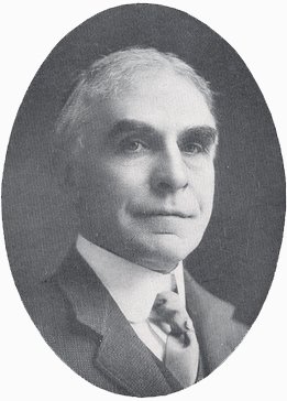
Chief Elijah Elk in the late 1920's knew of the past and some of the failed or fraudulent items that came out of the treaties of 1855 and 1864. Attending a summer Camp Meeting at Delwin he started to once again organize the band to achieve some equity of past injustices. It would be 1937 before many Indian grievances were seriously addressed by the United States government. In the spring of that year, options were taken on 410 acres three miles east of Mt. Pleasant. The present reservation program was initiated along with establishment of a Tribal Council.
Elijah Elk explained the injustices to the tribe but also was successful in getting his story before the general public. In a 1932 newspaper story he stated; "Federal agents worked in league with persons interested in obtaining lumber concessions and thereby tricked the tribe out of thousands of dollars. Many of the lands awarded by the government to Indians were to Indians that never existed or long had been dead so that lumber rights could be obtained," was one charge he leveled. The Chief supported this with "tombstone records". Further claims were set forth, concerning patents that were issued to persons dead many years before the award was made, along with other grants that were made to Indians that never lived in this part of the state.
The remarks of Mrs. Mosher, Rev. Bradley, and Chief Elijah Elk serve to our present-day citizens a not too pleasant point of reflection. The higher values, such as concern for the well being of others and the environment, was in the minds of those who drafted the treaty of 1855. In retrospect, the results left much to be desired. In this author's mind a phrase from Rev. Bradley keeps coming back: "The love of money has infused others to act in their own employment even at the destruction of the Indians." We would wish those who carry out decisions to see themselves as servants of the group and entrusted with responsibility. If this had been the case the success of the early Indian Treaties of Isabella County would have been greatly enhanced.
Bibliography
Atlas of Isabella County Michigan, 1879. (Philadelphia: C.O. Titus, 1879).
Atlas of Michigan, 1873. (Walling: R.M. Tackabury, 1873).
Central Michigan Times. February 2, 1906; April 23, 1909; June 15, 1909; May 11, 1910; June 17, 1910.
Detroit Advertiser & Tribune, February 9, 1863.
Fancher, Issac A., Past and Present of Isabella County Michigan. (Indianapolis: B.F. Bowen & Company, 1911).
Goodstein, A.S., Biography of a Businessman, Henry Sage. (Ithaca, NY: Cornell University Press, 1962).
Isabella County Michigan Portrait & Biographical Album. (Chicago: Chapman Brothers, 1884).
Isabella County Enterprise. March 29, 1876; August 17, 1881; March 24, 1893; May 24, 1895; May 8, 1914; April 12, 1918; September 25, 1925; April 14, 1927.
Mills, James C., History of Saginaw County Michigan. (Saginaw: Seeman & Peters, 1918).
Mount Pleasant Daily Bulletin, August 27, 1894.
Mount Pleasant Times, January 23, 1926.
Mount Pleasant Times News, June 11, 1931; June 25, 1931; February 25, 1937; March 18, 1937; December 8, 1938; March 7, 1940; November 20, 1941; December 4, 1941; June 3, 1948; May 9, 1958.
National Archives Microfilm M234 R413:0011-0047
Brooks to COIA - 1/18/1878
E.J. Brooks, Special Agent's report on his investigation into the Isabella Indian Reservation as reported to the Commissioner Of Indian Affairs, (COIA)
Northwestern Tribune (Mt. Pleasant), booklet, "Farming in Isabella County," 1889.
Northwestern Tribune, February 24, 1888; March 2, 1888; March 9, 1888; March 30, 1888; April 27, 1888.
Powers, Ella V., manuscript collection, Clarke Historical Library, Central Michigan University.
Publication 49, Surface Formations of Southern Michigan. (Lansing: Michigan Geological Survey, 1955).
Saginaw Daily Enterprise, June 20, 1871.
Saginaw Daily Courier, April 27, 1872; October 13, 1872.
About the Author
Mr. Keenan is a long-time resident of Mount Pleasant. He received his undergraduate education at Central Michigan University and, until he retired, taught Earth Sciences in the Mt. Pleasant Public Schools. He has also assumed a number of leadership posts within the community, including serving as mayor. Throughout these many activities he has nurtured an ongoing interest in the community's past and as a result has researched a wide ranging body of publications to learn more about Mount Pleasant. In turn, he has shared what he has learned through a series of publications.
Mr. Keenan's wife Ann is also a graduate of Central and before her retirement served as an educator both at the University and within the public schools. Together they have raised four children, and now enjoy their first grandchild.